
Off roading tips/ observations?

CF Veteran
Joined: Aug 2008
Posts: 6,588
Likes: 495
From: Chico, CA
Year: 1986
Model: Cherokee
Engine: 4.3L with headers and full 3" exhaust system
Cell phone yes, FM radio sure but nix that flare. Unless you want to be found as the cause of a wild fire. But remember, you may be somewhere where there is no cell service. In a pinch you can get on top of a tall mountain and sometimes get one bar.
CF Veteran
Joined: Aug 2008
Posts: 6,588
Likes: 495
From: Chico, CA
Year: 1986
Model: Cherokee
Engine: 4.3L with headers and full 3" exhaust system
Tip #6 Know where you are going and tell someone about it. This involves doing some homework and planning your trip. You should learn to read topographic maps. The whole country has been mapped, and as far as that goes, the whole world.
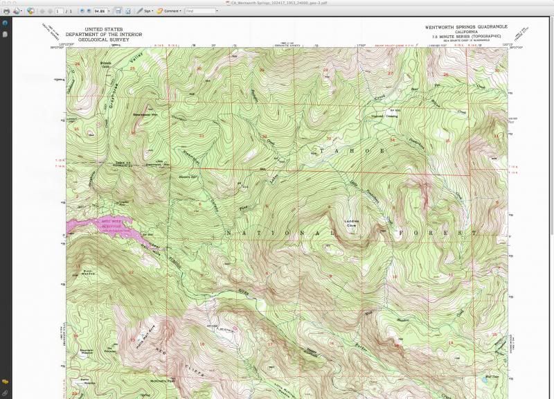
You can get these maps for free at usgs.gov. The website is not as easy to use as before they improved it.
However there is another cool source:
https://www.natgeomaps.com/trail-maps/pdf-quads
Once you have downloaded your maps and study them, you can print them and make a map book to carry with you.
After that, you can get a cheap app for your phone called Backcountry Navigator that uses these same free maps. Download the maps to your phone and use them to locate and track yourself
Thread Starter
Seasoned Member
Joined: Dec 2016
Posts: 307
Likes: 0
From: Cranston, Rhode Island/Swansea, Massachusetts
Year: 1999/1995
Model: Cherokee (XJ)
Engine: 4.0L
CB radio not FM I just mentioned the flare cause it's in some of the old emergency kits, I wouldn't use one cause like you said forest fire is not a good thing
CF Veteran
Joined: May 2015
Posts: 4,481
Likes: 18
From: Arizona
Year: 97
Model: Cherokee
Engine: 4.0
Tip #6 Know where you are going and tell someone about it. This involves doing some homework and planning your trip. You should learn to read topographic maps. The whole country has been mapped, and as far as that goes, the whole world.
You can get these maps for free at usgs.gov. The website is not as easy to use as before they improved it.
However there is another cool source:
https://www.natgeomaps.com/trail-maps/pdf-quads
Once you have downloaded your maps and study them, you can print them and make a map book to carry with you.
After that, you can get a cheap app for your phone called Backcountry Navigator that uses these same free maps. Download the maps to your phone and use them to locate and track yourself
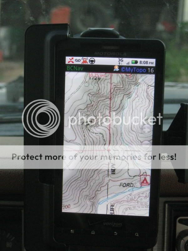
Here is a site I have been using for years now and it's free. they can be printed out from the topo server.
https://www.mytopo.com/maps/index.cfm
CF Veteran
Joined: Aug 2008
Posts: 6,588
Likes: 495
From: Chico, CA
Year: 1986
Model: Cherokee
Engine: 4.3L with headers and full 3" exhaust system
Yup, but people are getting lazy nowadays. They just rely on the GPS and don't realize most of them rely on a phone tower to work. Any of the Google based stuff is that way. Many of the dedicated GPS maps don't have the topographic feature, just roads and location. I think this is the best bang for the buck. It is also how I find cool places to wheel. The map on the phone is a nice trail that was once paved but now requires lockers and is not on any of the digital trail map web sites
CF Veteran
Joined: May 2015
Posts: 4,481
Likes: 18
From: Arizona
Year: 97
Model: Cherokee
Engine: 4.0
Yup, but people are getting lazy nowadays. They just rely on the GPS and don't realize most of them rely on a phone tower to work. Any of the Google based stuff is that way. Many of the dedicated GPS maps don't have the topographic feature, just roads and location. I think this is the best bang for the buck. It is also how I find cool places to wheel. The map on the phone is a nice trail that was once paved but now requires lockers and is not on any of the digital trail map web sites
Thread Starter
Seasoned Member
Joined: Dec 2016
Posts: 307
Likes: 0
From: Cranston, Rhode Island/Swansea, Massachusetts
Year: 1999/1995
Model: Cherokee (XJ)
Engine: 4.0L
CF Veteran
Joined: May 2015
Posts: 4,481
Likes: 18
From: Arizona
Year: 97
Model: Cherokee
Engine: 4.0
FM is a HAM band. You can buy radios with both bands, AM CB band and 10 meter FM. But... You are supposed to have a license to key up on 10 meter. There are FRS FM frequencies but they don't travel much farther than a CB because they are "Line of sight" and get blocked pretty easy.
Thread Starter
Seasoned Member
Joined: Dec 2016
Posts: 307
Likes: 0
From: Cranston, Rhode Island/Swansea, Massachusetts
Year: 1999/1995
Model: Cherokee (XJ)
Engine: 4.0L
FM is a HAM band. You can buy radios with both bands, AM CB band and 10 meter FM. But... You are supposed to have a license to key up on 10 meter. There are FRS FM frequencies but they don't travel much farther than a CB because they are "Line of sight" and get blocked pretty easy.
CF Veteran
Joined: May 2015
Posts: 4,481
Likes: 18
From: Arizona
Year: 97
Model: Cherokee
Engine: 4.0
On FM I'm talking to Alaska from Az when the conditions are right.

Thread Starter
Seasoned Member
Joined: Dec 2016
Posts: 307
Likes: 0
From: Cranston, Rhode Island/Swansea, Massachusetts
Year: 1999/1995
Model: Cherokee (XJ)
Engine: 4.0L
Definitely! The ranger is really good, my CB is a bearcat 880. Which is impressive when you consider the antenna is only a 4 foot magnetic
CF Veteran
Joined: May 2015
Posts: 4,481
Likes: 18
From: Arizona
Year: 97
Model: Cherokee
Engine: 4.0
I run a full steel whip because it gets HOT when I key up for any length of time. On high It will melt the plastic off the outside of fiberglass antennas and the element comes unwound.. lol
Thread Starter
Seasoned Member
Joined: Dec 2016
Posts: 307
Likes: 0
From: Cranston, Rhode Island/Swansea, Massachusetts
Year: 1999/1995
Model: Cherokee (XJ)
Engine: 4.0L
CF Veteran
Joined: May 2015
Posts: 4,481
Likes: 18
From: Arizona
Year: 97
Model: Cherokee
Engine: 4.0