Jeep Cherokee Forum
  • LOG IN
  • REGISTER
  • Forums
    • Technical Discussion
      • Stock XJ Cherokee Tech. All XJ Non-modified/stock questions go here
      • Modified XJ Cherokee Tech
      • MJ Comanche Tech. Stock & Modified.
      • KL Cherokee Tech
      • Modified Grand Cherokee Tech. All ZJ,WJ & WK aftermarket tech goes here
      • Stock Grand Cherokee Tech. All ZJ/WJ/WK Non-modified/stock questions go here!
      • Fabrication & builders section.
      • Jeep Builds
      • Aftermarket electrical systems
      • Jeep JK Model Discussion
      • Other Vehicles. Other Jeep models & cars and trucks of other makes
      • Technical Write-Up/How To Section
    • General
      • Introductions
      • Cherokee Chat
      • Cherokee of the Month
    • Wheeling Neighborhoods
      • Pacific Northwest
      • Pacific Southwest
      • Northern Rockies
      • Four Corners
      • Midwest
      • South Central
      • Great Lakes
      • Southeast
      • North Atlantic
      • Mid Atlantic
      • International
    • Wheeling Discussion
      • Trail Reports
      • Land Use Forum
    • Buy, Sell, Trade
      • Non-Cherokee Parts
      • Vendor Showcase
      • Vehicles
      • Axles/Tires/Wheels
      • Engines/Tranny/T-Case
      • Suspension/Steering
      • Accessories
      • Part Outs
      • Miscellaneous
      • Wanted
    • CF Announcements & Suggestions
      • Announcements
      • CF Suggestions & Questions
      • Test Section
  • Marketplace
    • Vendor Directory
    • Become a Vendor
    • Member Marketplace
    • Vendor Marketplace
  • New Posts
  • Tools
    • Car Payment Calculator
    • Tire Rim Calculator
    • Vin Decoder
    • Recalls
    • Technical Service Bulletins (TSBs)
    • Members List
    • Live Feed
  • How-Tos
  • Gallery
  • View Dark Mode
    • Please register or login to enable Dark Mode.
  • Log In
  • Register
Jeep Cherokee Forum
    • Threads
      • Advanced
Dark Mode

Please register or login to enable Dark Mode.

Log In

Forgot your Password?

By logging into your account, you agree to our Terms of Use and Privacy Policy, and to the use of cookies as described therein.
or
 
  • Recent
  • Commented
  • Albums
  • My Pictures

Ouray Colorado 3

radio flyer
October 10, 2012
 85
 0
Description:
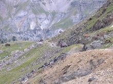
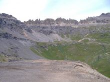
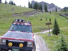
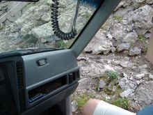
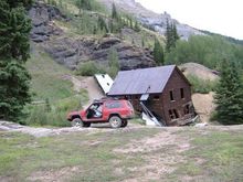
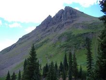
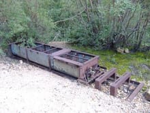
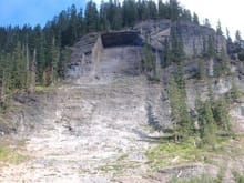
Another week in heaven, Details as time allows

Read more ยป
Sort:
Default
  • Default
  • Most Recent
Governor Basin Road, Virginius Mine
My junk @ 12,170' getting ready to cross the off camber- narrow- tipsy- washed out section. My wife, both of my boys and my mother in law would not ride with me thru this section! Looking north east
Governor Basin Road, Virginius Mine My junk @ 12,170' getting ready to cross the off camber- narrow- tipsy- washed out section. My wife, both of my boys and my mother in law would not ride with me thru this section! Looking north east
0 2012/10/10 22:13:44 radio flye
Governor Basin Road, Virginius Mine
The sky line in Governor Basin is amazing!! Zoom in to see the shack below the top of the ridge. Looking south east
Governor Basin Road, Virginius Mine The sky line in Governor Basin is amazing!! Zoom in to see the shack below the top of the ridge. Looking south east
0 2012/10/10 22:13:44 radio flye
Governor Basin Road, Virginius Mine
A rock from above, the sky line in Governor Basin is amazing!! 12,168'
Governor Basin Road, Virginius Mine A rock from above, the sky line in Governor Basin is amazing!! 12,168'
0 2012/10/10 22:13:44 radio flye
Governor Basin Road, Virginius Mine
Mendota Peak 13,276' in upper left, St. Sophia Ridge 12,800' in upper center, Mount Emma 13,581' in upper right.The trail coming in from the right, and climbing to the center takes you to the Governor Mine @ 12,620', and the Humbolt Mine @ 12,664'
Governor Basin Road, Virginius Mine Mendota Peak 13,276' in upper left, St. Sophia Ridge 12,800' in upper center, Mount Emma 13,581' in upper right.The trail coming in from the right, and climbing to the center takes you to the Governor Mine @ 12,620', and the Humbolt Mine @ 12,664'
0 2012/10/10 22:13:44 radio flye
Governor Basin Road, Virginius Mine
Looking north east @ 12,200' towards Teakettle Mountain, and Potosi Peak.
Governor Basin Road, Virginius Mine Looking north east @ 12,200' towards Teakettle Mountain, and Potosi Peak.
0 2012/10/10 22:13:44 radio flye
Governor Basin Road, Virginius Mine
This old boiler is still in pretty good condition for being over 100 years old.. Looking north east
Governor Basin Road, Virginius Mine This old boiler is still in pretty good condition for being over 100 years old.. Looking north east
0 2012/10/10 22:15:51 radio flye
Governor Basin Road, Virginius Mine
My youngest JAYCE - 5 at the time- decided that this ore cart was an old choo choo train, and climbed in for a ride!! Fact is- ore carts are part of a small train used to haul ore and tailing out of the mine!! The old boiler in the back ground is still in pretty good condition for being over 100 years old.. Looking south east
Governor Basin Road, Virginius Mine My youngest JAYCE - 5 at the time- decided that this ore cart was an old choo choo train, and climbed in for a ride!! Fact is- ore carts are part of a small train used to haul ore and tailing out of the mine!! The old boiler in the back ground is still in pretty good condition for being over 100 years old.. Looking south east
0 2012/10/10 22:15:51 radio flye
Governor Basin Road, Virginius Mine
My youngest JAYCE - 5 at the time- decided that this ore cart was an old choo choo train, and climbed in for a ride!! Looking south east
Governor Basin Road, Virginius Mine My youngest JAYCE - 5 at the time- decided that this ore cart was an old choo choo train, and climbed in for a ride!! Looking south east
0 2012/10/10 22:15:51 radio flye
Governor Basin Road, Sydney Basin turn
Which way to go ? Looking south, the peaks at top center are the peaks in my pictures at the Virginius Mine and reach just over 13,200'.
Governor Basin Road, Sydney Basin turn Which way to go ? Looking south, the peaks at top center are the peaks in my pictures at the Virginius Mine and reach just over 13,200'.
0 2012/10/10 22:15:51 radio flye
Governor Basin Road
This doe was feeding her fawns when she caught my eye. There is another picture in my album with her fawns.
Governor Basin Road This doe was feeding her fawns when she caught my eye. There is another picture in my album with her fawns.
0 2012/10/10 22:15:51 radio flye
Governor Basin Road, Sweepstakes Mine
Between a mountain and a cliff.
Governor Basin Road, Sweepstakes Mine Between a mountain and a cliff.
0 2012/10/10 22:17:13 radio flye
Governor Basin Road
Between a mountain and a cliff.
Governor Basin Road Between a mountain and a cliff.
0 2012/10/10 22:17:13 radio flye
Governor Basin Road
Taking in the sights.
Governor Basin Road Taking in the sights.
0 2012/10/10 22:17:13 radio flye
Governor Basin Road
Taking in the sights. My wife AMY, my youngest JAYCE, and me taking the picture. Who needs both hands on the wheel while on a shelf road ? According to my wife I DO!!!!
Governor Basin Road Taking in the sights. My wife AMY, my youngest JAYCE, and me taking the picture. Who needs both hands on the wheel while on a shelf road ? According to my wife I DO!!!!
0 2012/10/10 22:17:13 radio flye
Governor Basin Road
The trail climbs 1,488' from the trail head in Yankee Boy Basin to the Virginius Mine. A distance of 1 mile as a bird fly's but 5.8 miles of twisting switch backs, so you get the picture of how fast you gain altitude!
Governor Basin Road The trail climbs 1,488' from the trail head in Yankee Boy Basin to the Virginius Mine. A distance of 1 mile as a bird fly's but 5.8 miles of twisting switch backs, so you get the picture of how fast you gain altitude!
0 2012/10/10 22:17:13 radio flye
Governor Basin Road
Looking east at the Revenue-Virginius Mine, 1,000' below.
Governor Basin Road Looking east at the Revenue-Virginius Mine, 1,000' below.
0 2012/10/10 22:19:04 radio flye
Governor Basin Road
Governor Basin Road
0 2012/10/10 22:19:04 radio flye
Yankee Boy Basin, Torpedo Eclipse Mine
0 2012/10/10 22:19:04 radio flye
Yankee Boy Basin, Revenue-Virginius Mine
This mine is prepping the site in order to reopen operations.Operation officially got underway on Oct. 19, 2011. In its heyday, the mine was a profitable venture, producing more than 14.5 million ounces of silver between 1876 and the late 1940s. It weathered the Silver Panic of 1893 while many other silver mines in the region and across the west failed.
Yankee Boy Basin, Revenue-Virginius Mine This mine is prepping the site in order to reopen operations.Operation officially got underway on Oct. 19, 2011. In its heyday, the mine was a profitable venture, producing more than 14.5 million ounces of silver between 1876 and the late 1940s. It weathered the Silver Panic of 1893 while many other silver mines in the region and across the west failed.
0 2012/10/10 22:19:04 radio flye
Yankee Boy Basin, Torpedo Eclipse Mine
0 2012/10/10 22:19:04 radio flye
Yankee Boy Basin, Torpedo Eclipse Mine
JAYCE 5 and TYLER 12, on the hunt.
Yankee Boy Basin, Torpedo Eclipse Mine JAYCE 5 and TYLER 12, on the hunt.
0 2012/10/10 22:20:50 radio flye
Yankee Boy Basin, Torpedo Eclipse Mine
A peak inside the slowly collapsing building.
Yankee Boy Basin, Torpedo Eclipse Mine A peak inside the slowly collapsing building.
0 2012/10/10 22:20:50 radio flye
Camp Bird Road
JAYCE--My co-pilot for the afternoon. 2012/08/04 15:32:09 He and i went up into Yankee Boy Basin looking for GOLD !
Camp Bird Road JAYCE--My co-pilot for the afternoon. 2012/08/04 15:32:09 He and i went up into Yankee Boy Basin looking for GOLD !
0 2012/10/10 22:20:50 radio flye
Yankee Boy Basin
JAYCE--My co-pilot for the afternoon.
Yankee Boy Basin JAYCE--My co-pilot for the afternoon.
0 2012/10/10 22:20:50 radio flye
Yankee Boy Basin
Looking south- south east at Stony Mountain- 12,698'
Yankee Boy Basin Looking south- south east at Stony Mountain- 12,698'
0 2012/10/20 13:38:02 radio flye
Yankee Boy Basin
Looking west at Gilpin Peak - 13,694'
Yankee Boy Basin Looking west at Gilpin Peak - 13,694'
0 2012/10/20 13:38:02 radio flye
Yankee Boy Basin
JAYCE--My co-pilot for the afternoon, just had to check out the remains of a digger!
Yankee Boy Basin JAYCE--My co-pilot for the afternoon, just had to check out the remains of a digger!
0 2012/10/20 13:38:02 radio flye
Yankee Boy Basin
JAYCE--My co-pilot for the afternoon.
Yankee Boy Basin JAYCE--My co-pilot for the afternoon.
0 2012/10/20 13:38:02 radio flye
Yankee Boy Basin
Machinery that looks like it was used in the amalgamation process to remove silver or gold from the ore.
Yankee Boy Basin Machinery that looks like it was used in the amalgamation process to remove silver or gold from the ore.
0 2012/10/20 13:38:02 radio flye
Yankee Boy Basin, Torpedo Eclipse Mine
Machinery that looks like it was used in the amalgamation process to remove silver or gold from the ore.
Yankee Boy Basin, Torpedo Eclipse Mine Machinery that looks like it was used in the amalgamation process to remove silver or gold from the ore.
0 2012/10/20 13:45:51 radio flye
Camp Bird Road
A massive portion of this mountain fell off into the canyon. On the south side of Canyon Creek is the Waterhole Slide, an avalanche that frequently closes the road with snow depths of 20 feet or more(More, 2004). The broken vegetation is a reflection of the distructive force of avalanches
Camp Bird Road A massive portion of this mountain fell off into the canyon. On the south side of Canyon Creek is the Waterhole Slide, an avalanche that frequently closes the road with snow depths of 20 feet or more(More, 2004). The broken vegetation is a reflection of the distructive force of avalanches
0 2012/10/20 13:45:51 radio flye
Camp Bird Road
The boulder looks like the stick underneath it is holding it in place!
Camp Bird Road The boulder looks like the stick underneath it is holding it in place!
0 2012/10/20 13:45:51 radio flye
Imogene Pass, Camp Bird Mine
Looking down into Lower Camp Bird.
Imogene Pass, Camp Bird Mine Looking down into Lower Camp Bird.
0 2012/10/20 13:45:51 radio flye
Imogene Pass, Camp Bird Mine
Looking down into Lower Camp Bird.
Imogene Pass, Camp Bird Mine Looking down into Lower Camp Bird.
0 2012/10/20 13:51:24 radio flye
Imogene Pass, Yellow Rose Mine
Warning sign at the Yellow Rose Mine-- The trail gets tougher from here to the pass, and down into Savage Basin.
Imogene Pass, Yellow Rose Mine Warning sign at the Yellow Rose Mine-- The trail gets tougher from here to the pass, and down into Savage Basin.
0 2012/10/20 13:51:24 radio flye
Imogene Pass, Yellow Rose Mine
Tyler scouting at the Yellow Rose Mine. 10,770'
Imogene Pass, Yellow Rose Mine Tyler scouting at the Yellow Rose Mine. 10,770'
0 2012/10/20 13:51:24 radio flye
Imogene Pass
I love going door-less on the trails!
Imogene Pass I love going door-less on the trails!
0 2012/10/20 13:51:24 radio flye
Imogene Pass, Yellow Rose Mine
Water fall on Imogene Creek above the Yellow Rose Mine. Standing at 10,828'.
Imogene Pass, Yellow Rose Mine Water fall on Imogene Creek above the Yellow Rose Mine. Standing at 10,828'.
0 2012/10/20 13:51:24 radio flye
First
Page
2 of 3
Last
Go To
Page
  • 1
  • 2
  • 3
2 of 3
Go To GO
Go to page of 3 pages
  • 1
  • 2
  • 3

Top
Jeep Cherokee Forum
  • Contact Us
  • FAQ
  • Archive
  • Advertising
  • Cookie Policy
  • Privacy Statement
  • Terms of Service
  • Your Privacy Choices
  • Manage Preferences

© 2026 MH Sub I, LLC dba Internet Brands


When you click on links to various merchants on this site and make a purchase, this can result in this site earning a commission. Affiliate programs and affiliations include, but are not limited to, the eBay Partner Network.